Petra (Greek "πέτρα" (petra), meaning rock; Arabic: البتراء, Al-Batrāʾ) is an archaeological site in the Arabah, Ma'an Governorate, Jordan, lying on the slope of Mount Hor[1] in a basin among the mountains which form the eastern flank of Arabah (Wadi Araba), the large valley running from the Dead Sea to the Gulf of Aqaba. It is renowned for its rock-cut architecture. Petra is also one of the New Seven Wonders of the World. The Nabataeans constructed it as their capital city around 100 BCE.[2]
The site remained unknown to the Western world until 1812, when it was introduced to the West by Swiss explorer Johann Ludwig Burckhardt. It was famously described as "a rose-red city half as old as time" in a Newdigate prize-winning sonnet by John William Burgon. UNESCO has described it as "one of the most precious cultural properties of man's cultural heritage."[3] In 1985, Petra was designated a World Heritage Site.
Geography
Pliny the Elder and other writers identify Petra as the capital of the Nabataeans, Aramaic-speaking Semites, and the centre of their caravan trade. Enclosed by towering rocks and watered by a perennial stream, Petra not only possessed the advantages of a fortress, but controlled the main commercial routes which passed through it to Gaza in the west, to Bosra and Damascus in the north, to Aqaba and Leuce Come on the Red Sea, and across the desert to the Persian Gulf.
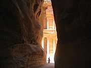
The end of the Siq, with its dramatic view of Al Khazneh ("The Treasury").
Excavations have demonstrated that it was the ability of the
Nabataeans to control the water supply that led to the rise of the
desert city, creating an artificial oasis. The area is visited by flash floods and archaeological evidence demonstrates the Nabataeans controlled these floods by the use of dams, cisterns and water conduits. These innovations stored water for prolonged periods of drought, and enabled the city to prosper from its sale.[4][5]
Although in ancient times Petra might have been approached from the south via Saudi Arabia on a track leading around Jabal Haroun
("Aaron's Mountain"), across the plain of Petra, or possibly from the
high plateau to the north, most modern visitors approach the site from
the east. The impressive eastern entrance leads steeply down through a
dark, narrow gorge (in places only 3ñ4 metres wide) called the Siq ("the shaft"), a natural geological feature formed from a deep split in the sandstone rocks and serving as a waterway flowing into Wadi Musa. At the end of the narrow gorge stands Petra's most elaborate ruin, Al Khazneh (popularly known as "the Treasury"), hewn into the sandstone cliff.
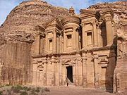
El Deir ("The Monastery").
A little further from the Treasury, at the foot of the mountain called en-Nejr,
is a massive theatre, so placed as to bring the greatest number of
tombs within view. At the point where the valley opens out into the
plain, the site of the city is revealed with striking effect. The amphitheatre
has been cut into the hillside and into several of the tombs during its
construction. Rectangular gaps in the seating are still visible. Almost
enclosing it on three sides are rose-colored mountain walls, divided
into groups by deep fissures, and lined with knobs cut from the rock in
the form of towers.
History
Evidence suggests that settlements had begun in and around Petra in the eighteenth dynasty of Egypt. It is listed in Egyptian campaign accounts and the Amarna letters
as Pel, Sela or Seir. Though the city was founded relatively late, a
sanctuary existed there since very ancient times. Stations 19 through
26 of the stations list of Exodus are places associated with Petra.[6] This part of the country was biblically assigned to the Horites, the predecessors of the Edomites.[7]
The habits of the original natives may have influenced the Nabataean
custom of burying the dead and offering worship in half-excavated
caves. Although Petra is usually identified with Sela which also means a rock, the Biblical references[8] refer to it as "the cleft in the rock", referring to its entrance. 2 Kings
xiv. 7 seems to be more specific. In the parallel passage, however,
Sela is understood to mean simply "the rock" (2 Chr. xxv. 12, see LXX).
On the authority of Josephus (Antiquities of the Jews iv. 7, 1~ 4, 7) Eusebius and Jerome (Onom. sacr. 286, 71. 145, 9; 228, 55. 287, 94) assert that Rekem was the native name and Rekem appears in the Dead Sea scrolls[9] as a prominent Edom site most closely describing Petra and associated with Mount Seir. But in the Aramaic versions Rekem is the name of Kadesh, implying that Josephus may have confused the two places.[citation needed] Sometimes the Aramaic versions give the form Rekem-Geya
which recalls the name of the village El-ji, southeast of Petra. The
capital, however, would hardly be defined by the name of a neighboring
village.[citation needed] The Semitic name of the city, if not Sela, remains unknown. The passage in Diodorus Siculus (xix. 94ñ97) which describes the expeditions which Antigonus sent against the Nabataeans in 312 BCE is understood to throw some light upon the history of Petra,[citation needed]
but the "petra" referred to as a natural fortress and place of refuge
cannot be a proper name and the description implies that the town was
not yet in existence.[citation needed]
The Rekem Inscription in 1976
The only place in Petra where the name "Rekem" occurs was in the
rock wall of the Wadi Musa opposite the entrance to the Siq. About
twenty years ago the Jordanians built a bridge over the wadi and this
inscription is now buried beneath tons of concrete.[10]
More satisfactory evidence of the date of the earliest Nabataean
settlement may be obtained from an examination of the tombs. Two types
may be distinguished: the Nabataean and the Greco-Roman. The Nabataean type starts from the simple pylon-tomb
with a door set in a tower crowned by a parapet ornament, in imitation
of the front of a dwelling-house. Then, after passing through various
stages, the full Nabataean type is reached, retaining all the native
features and at the same time exhibiting characteristics which are
partly Egyptian and partly Greek.
Of this type there exist close parallels in the tomb-towers at el-I~ejr
in north Arabia, which bear long Nabataean inscriptions and supply a
date for the corresponding monuments at Petra. Then comes a series of
tombfronts which terminate in a semicircular arch, a feature derived
from north Syria. Finally come the elaborate faÁades copied from the front of a Roman temple;
however, all traces of native style have vanished. The exact dates of
the stages in this development cannot be fixed. Strangely, few
inscriptions of any length have been found at Petra, perhaps because
they have perished with the stucco or cement which was used upon many
of the buildings. The simple pylon-tombs which belong to the
pre-Hellenic age serve as evidence for the earliest period. It is not
known how far back in this stage the Nabataean settlement goes, but it
does not go back farther than the 6th century BCE.
A period follows in which the dominant civilization combines Greek,
Egyptian and Syrian elements, clearly pointing to the age of the Ptolemies. Towards the close of the 2nd century BCE, when the Ptolemaic and Seleucid kingdoms were equally depressed, the Nabataean kingdom came to the front. Under Aretas III Philhellene,
(c.85ñ60 BCE), the royal coins begin. The theatre was probably
excavated at that time, and Petra must have assumed the aspect of a Hellenistic city. In the reign of Aretas IV Philopatris, (9 BCEñ40 CE), the fine tombs of the el-I~ejr [?] type may be dated, and perhaps also the great High-place.
Roman rule
In 106 CE, when Cornelius Palma was governor of Syria, that part of Arabia under the rule of Petra was absorbed into the Roman Empire as part of Arabia Petraea, becoming capital. The native dynasty came to an end. But the city continued to flourish. A century later, in the time of Alexander Severus,
when the city was at the height of its splendor, the issue of coinage
comes to an end. There is no more building of sumptuous tombs, owing
apparently to some sudden catastrophe, such as an invasion by the neo-Persian power under the Sassanid Empire. Meanwhile, as Palmyra
(fl. 130ñ270) grew in importance and attracted the Arabian trade away
from Petra, the latter declined. It seems, however, to have lingered on
as a religious centre. Epiphanius of Salamis (c.315ñ403) writes that in his time a feast was held there on December 25 in honor of the virgin Chaabou and her offspring Dushara (Haer. 51).[citation needed]
Religion
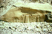
The Nabataeans worshipped the Arab gods and goddesses of the pre-Islamic times as well as few of their deified kings. The most famous of these was Obodas I who was deified after his death. Dushara was the main male god accompanied by his female trinity: Uzza, Allat and Manah. Many statues carved in the rock depict these gods and goddesses.
The Monastery, Petra's largest monument, dates from the first
century BCE. It was dedicated to Obodas I and is believed to be the
symposium of Obodas the god. This information is inscribed on the ruins
of the Monastery (the name is the translation of the Arabic "Ad-Deir").
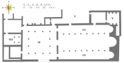
Plan of the Byzantine church, 5th century CE.
Christianity found its way to Petra in the 4th century CE, nearly 500 years after the establishment of Petra as a trade center. Athanasius mentions a bishop of Petra (Anhioch. 10) named Asterius.
At least one of the tombs (the "tomb with the urn"?) was used as a
church. An inscription in red paint records its consecration "in the
time of the most holy bishop Jason" (447). After the Islamic conquest of 629ñ632 Christianity in Petra, as of most of Arabia, gave way to Islam. During the First Crusade Petra was occupied by Baldwin I of the Kingdom of Jerusalem and formed the second fief of the barony of Al Karak (in the lordship of Oultrejordain) with the title Ch’teau de la ValÈe de Moyse or Sela. It remained in the hands of the Franks until 1189. It is still a titular see of the Roman Catholic Church.[11]
According to Arab tradition, Petra is the spot where Moses struck a rock with his staff and water came forth, and where Moses' brother, Aaron, is buried, at Mount Hor,
known today as Jabal Haroun or Mount Aaron. The Wadi Musa or "Wadi of
Moses" is the Arab name for the narrow valley at the head of which
Petra is sited. A mountaintop shrine of Moses' sister Miriam was still
shown to pilgrims at the time of Jerome in the fourth century, but its
location has not been identified since.[12]
Decline
Petra declined rapidly under Roman rule, in large part due to the
revision of sea-based trade routes. In 363 an earthquake destroyed many
buildings, and crippled the vital water management system.[13] The ruins of Petra were an object of curiosity in the Middle Ages and were visited by Sultan Baibars of Egypt towards the end of the 13th century. The first European to describe them was Johann Ludwig Burckhardt in 1812.
Because the structures weakened with age, many of the tombs
became vulnerable to thieves, and many treasures were stolen